Are you curious about the most heavily fortified border in the world? The Korean Demilitarized Zone (DMZ) is a 4-kilometer-wide buffer zone established on July 27, 1953, following the Korean War armistice, designed to prevent direct military conflict between North and South Korea. Spanning 248 kilometers (155 miles) from the Imjin River to the Goseong coast, it remains a frozen capsule of history, a high-stakes military flashpoint, and an unexpected ecological sanctuary. In this guide, I will take you through the deep history, the harrowing incidents that shaped this border, and the breathtaking wildlife that now calls this “no-man’s-land” home in 2026.
- The Origin of the DMZ: From the 38th Parallel to the MDL
- Comparing the 38th Parallel and the Military Demarcation Line
- Turning Points: High-Stakes Incidents in DMZ History
- The 2024-2026 Shift: Physical Severance and Fortification
- Nature’s Treasure House: The Biodiversity of the DMZ
- Planning Your Visit: DMZ Travel in 2026
The Origin of the DMZ: From the 38th Parallel to the MDL
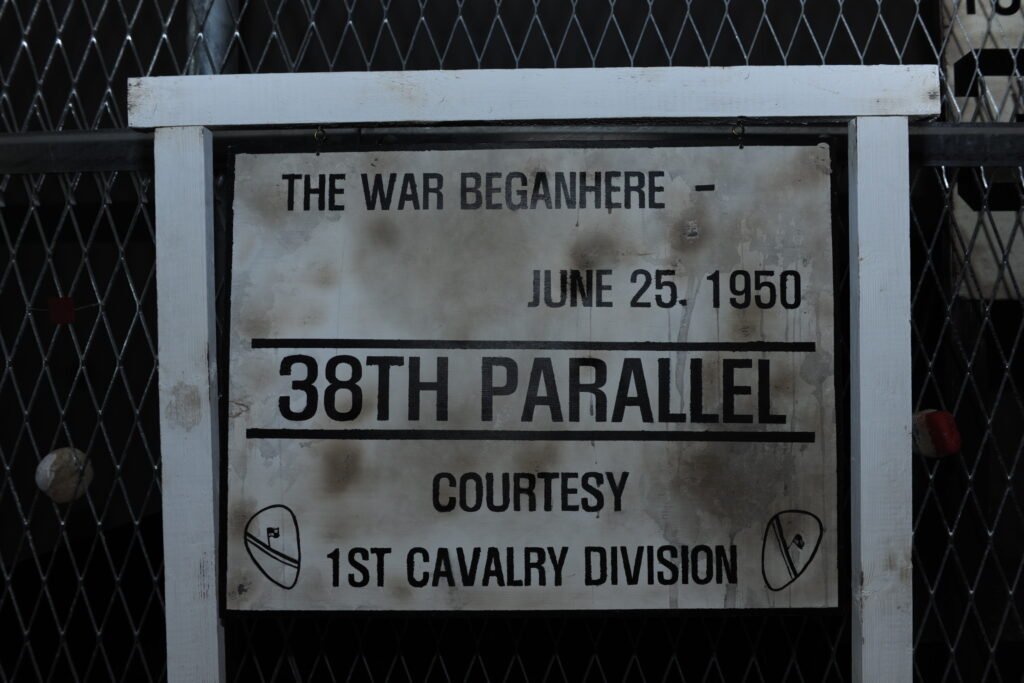
To understand the DMZ, we must look back at two distinct lines that changed the fate of the Korean Peninsula. The first was the 38th Parallel, an artificial boundary drawn in August 1945 by two U.S. colonels, Dean Rusk and Charles Bonesteel. Using a National Geographic map and only 30 minutes of deliberation, they chose this line to divide Soviet and American spheres of influence after World War II. Because it was a straight latitudinal line, it ignored local geography, literally cutting through villages and backyards.
The second line is the Military Demarcation Line (MDL), which is the actual border today. Unlike the straight 38th parallel, the MDL is a jagged “S” shape that follows the “Line of Contact” where troops were actually positioned when the ceasefire was signed in 1953. During the final years of the war, brutal “hill battles” were fought as both sides scrambled to gain even a few more meters of territory before the ink dried on the Armistice Agreement.
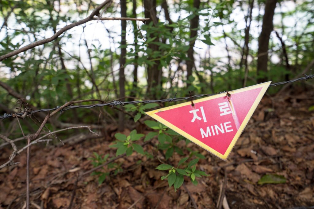
The DMZ itself was created by pushing both armies back 2 kilometers from this MDL, creating a 4-kilometer-wide “safety zone.” By treaty, no heavy weaponry or large military contingents are allowed inside this space, though in reality, it remains one of the most heavily mined areas on Earth.
Comparing the 38th Parallel and the Military Demarcation Line
| Feature | 38th Parallel (1945) | Military Demarcation Line (MDL, 1953) |
|---|---|---|
| Nature | Political boundary between US/USSR | Military border following the ceasefire |
| Basis | Latitude 38° North (Straight line) | Actual front line (Jagged/Zigzag) |
| Origin | Post-WWII division | Korean War Armistice Agreement |
| Duration | 1945 – 1950 (Nullified by war) | 1953 – Present |
Turning Points: High-Stakes Incidents in DMZ History
Over the last 70 years, the DMZ has been the stage for cinematic escapes and tragic confrontations. Living in Korea, we often hear these stories as reminders of the fragile peace we maintain. One of the most infamous was the 1976 Axe Murder Incident. When U.S. and South Korean soldiers attempted to trim a poplar tree that obstructed their view in the Joint Security Area (JSA), North Korean soldiers attacked with axes, killing two U.S. officers. This nearly sparked a full-scale war, leading to the permanent separation of personnel within the JSA.
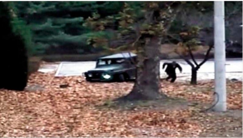
In more recent memory, the 2017 JSA Defection caught the world’s attention. A North Korean soldier, Oh Chong-song, drove a jeep toward the border and dashed across under a hail of bullets. He was rescued by South Korean troops in a daring undercover crawl. More recently, the 2023 Travis King incident—where a U.S. soldier bolted across the border during a civilian tour—reminded the global community that the DMZ remains a complex legal and diplomatic labyrinth.
💡 Local Note: These incidents are why security protocols at the DMZ are so strict. When you visit, you aren’t just seeing a tourist site; you are entering a zone where international law and military armistice rules are enforced every second.
The 2024-2026 Shift: Physical Severance and Fortification
As of 2026, the atmosphere at the border has entered a new phase of “fortification.” Beginning in late 2024, North Korea began a systematic effort to permanently sever all physical links with the South. This included the demolition of the Gyeongui and Donghae railway lines and roads that once symbolized hopes for reunification.
Currently, in 2026, we are seeing the construction of massive anti-tank walls and the large-scale laying of new landmines along the northern side of the DMZ. This “border hardening” marks a significant shift from the previous decade’s efforts at peace talks, turning the DMZ into a more rigid physical barrier than ever before. For travelers, this means that while the South remains safe and open for tours, the visual landscape of the border is more imposing and dramatic.
Nature’s Treasure House: The Biodiversity of the DMZ
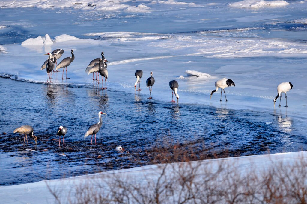
Paradoxically, the absence of humans for over seven decades has allowed nature to reclaim the DMZ. It has become a “Treasure House of Ecosystems,” hosting roughly 38% of South Korea’s endangered species. Without the interference of urban development, the DMZ serves as a vital ecological corridor connecting the east and west of the peninsula.
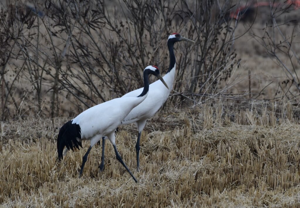
- Rare Birds: Every winter, the Red-crowned Crane (Natural Monument No. 202) and the White-naped Crane (No. 203) migrate to the DMZ’s wetlands, finding a rare peace in the middle of a military zone.
- Mammals: The rugged mountains are home to the Long-tailed Goral (Natural Monument No. 217), while the dense forests provide a habitat for Musk Deer and even Asiatic Black Bears.
- Pristine Flora: The DMZ contains wetlands and forests that have remained untouched since 1953, offering scientists a unique look at how nature heals itself.
Planning Your Visit: DMZ Travel in 2026
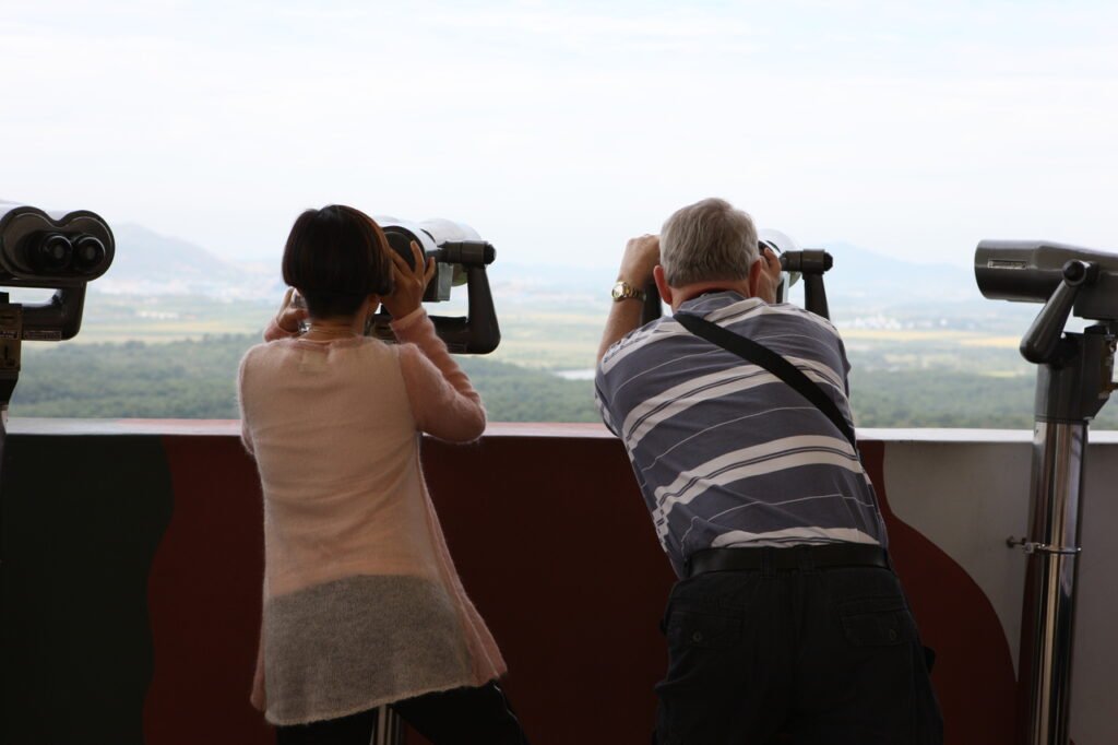
Visiting the DMZ in 2026 is a profound experience that blends history with the current geopolitical reality. Most tours depart from Seoul and focus on the Paju area, including the Third Tunnel and the Dora Observatory, where you can look directly into North Korea through binoculars.
If you’re interested in the logistics of a trip, check out our guide on How to Visit the Korean DMZ in 2026: Fees & Booking Guide. Because the security situation can change, tours are occasionally restricted on short notice, so I always recommend checking the status at least 48 hours before your planned departure.
DMZ Tour Quick Reference (2026)
| Site Name | Location | Key Experience |
|---|---|---|
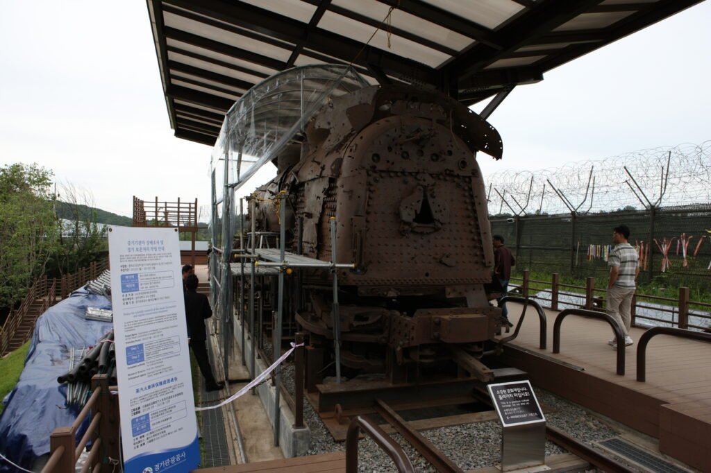
| The 3rd Infiltration Tunnel | Paju | Walking through a tunnel dug by the North for a surprise attack. |
| Dora Observatory | Paju | Using high-powered binoculars to see Kaesong City in North Korea. |
| Imjingak Park | Paju | The “Bridge of Freedom” and the Mangbaedan altar for separated families. |
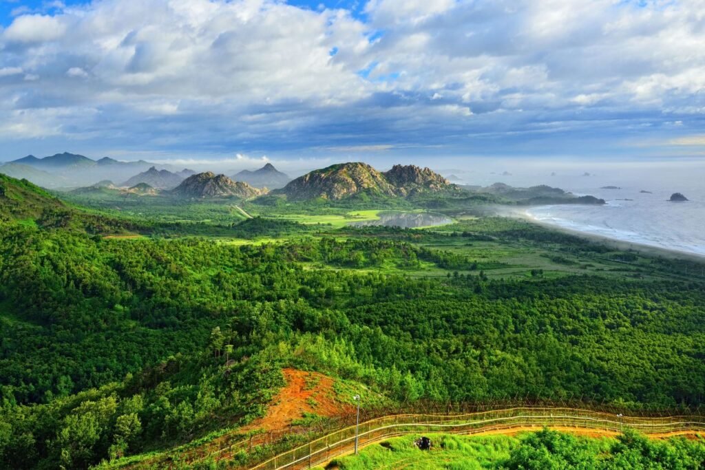
| Goseong Unification Tower | East Coast | Viewing the stunning Mount Kumgang in the North. |
FAQ
Is it safe to visit the DMZ?
Yes, the DMZ remains one of the most popular and safest tourist destinations in South Korea. While the North has fortified its side, the Southern tourist areas are strictly managed by the UN Command and the South Korean military to ensure visitor safety.
Can I visit the DMZ without a tour?
Most areas, especially the tunnels and observatories, require you to be part of an authorized tour group or use the official shuttle buses provided at Imjingak. You cannot simply drive into the DMZ on your own.
What should I bring for a DMZ tour?
The most important item is your Passport. Without it, you will be denied entry at the military checkpoints.
Korean Culture portal KCulture.com

Founder of Kculture.com and MA in Political Science. He shares deep academic and local insights to provide an authentic perspective on Korean history and society.