The 800-Year Story of Ganghwa Island Land Reclamation
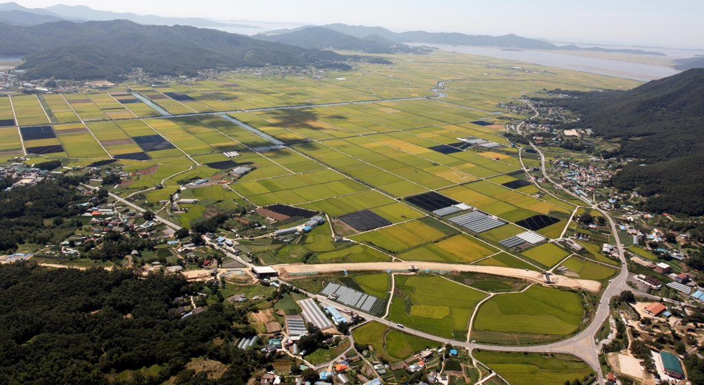
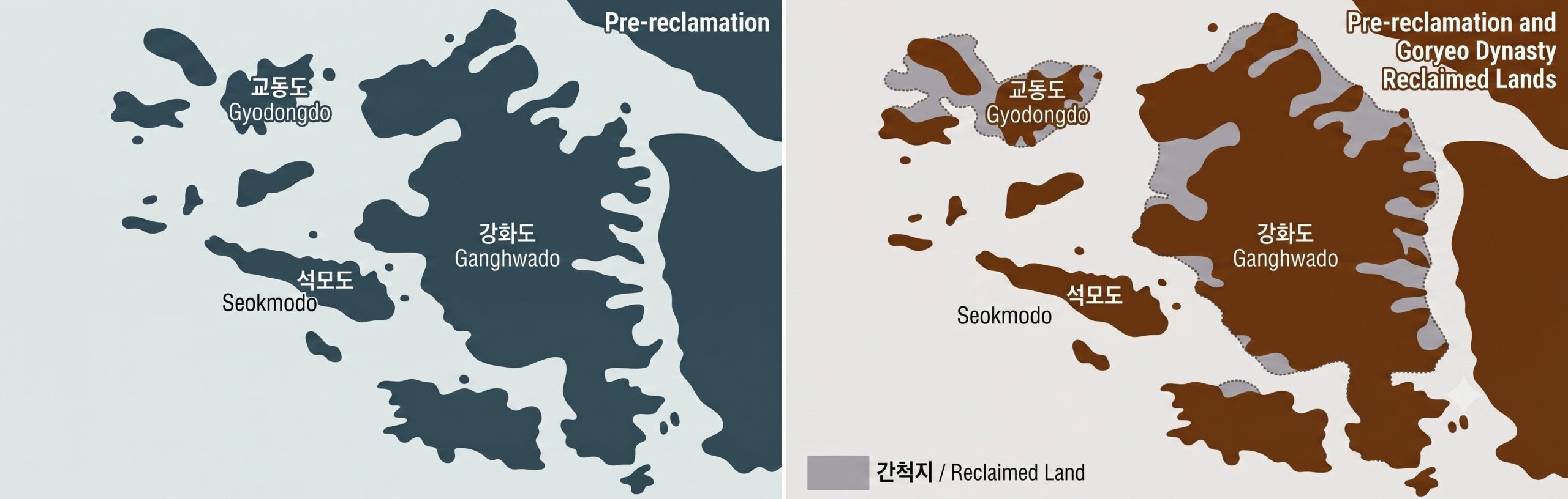
Ganghwa Island land reclamation is one of the oldest and most remarkable coastal engineering projects in East Asian history, beginning over 800 years ago during the Goryeo Dynasty. Originally driven not by commercial expansion but by a desperate need for military farmland against Mongol invasions, this centuries-long endeavor transformed a fragmented archipelago into a single massive landmass. Today, nearly 30% of the island consists of reclaimed land, turning former ocean tides into vast, golden rice fields.
For modern travelers standing amidst the peaceful agricultural plains of Ganghwa Island (강화도), it is difficult to imagine that the sea once rushed over this very soil. Living in Korea and observing the remnants of these ancient seawalls, one can truly appreciate the sheer scale of medieval survival engineering. This article explores how medieval Koreans fought the tides, how the Joseon Dynasty expanded the island’s borders, and where you can witness this fascinating historical paradox today.
- Why Ganghwa Became a Center for Land Reclamation
- The Goryeo Origins: Land Reclamation Born from War
- How Medieval Koreans Built the Seawalls
- Joseon Expanded the Project and Reshaped the Island
- The Historical Irony: When the Sea Disappeared
- Ganghwa vs. Global Land Reclamation Projects
- Places to Experience This History Today
- Explore More of Korea
Why Ganghwa Became a Center for Land Reclamation
Ganghwa has always occupied one of Korea’s most strategic locations. Sitting at the entrance to the Han River, it controlled the maritime approach to the capital for both the Goryeo Dynasty (고려시대) and the Joseon Dynasty (조선시대). Whoever held Ganghwa could influence access to the heart of the kingdom.
Its location made the island a natural fortress, but it also presented a serious problem. When enormous numbers of soldiers, officials, craftsmen, and refugees suddenly arrived during times of conflict, the rocky, hilly island simply did not have enough flat farmland to feed them.
📌 Local Note: Rather than viewing land reclamation as an economic development project, medieval Korea initially saw it as a matter of absolute national survival. Creating farmland meant sustaining the government and the resistance against one of history’s largest empires.
The Goryeo Origins: Land Reclamation Born from War
The Anti-Mongol Resistance (1232–1270) transformed Ganghwa into Korea’s temporary capital. Historians estimate that well over one hundred thousand people eventually gathered on the island, placing enormous pressure on local food production.
According to the Goryeosa (History of Goryeo), by 1256 the government had already begun constructing embankments to reclaim tidal flats and establish Tunjon (둔전)—military agricultural land dedicated to supplying grain for the army.
| Period | Main Event & Goal | Historical Significance |
|---|---|---|
| 1232 | Capital relocated to Ganghwa | Population surged dramatically, causing a massive food shortage. |
| 1256 | First recorded large-scale embankment | Marked the first documented military reclamation project in Korean history. |
| Late Goryeo | Expansion of reclaimed farmland | Set the technological foundation for future, larger reclamation projects. |
How Medieval Koreans Built the Seawalls
The tidal currents around Ganghwa are among the strongest on Korea’s west coast. Simply piling stones into the deep mud would have failed, as waves and currents would quickly wash them away.
Historical records describe an ingenious solution. Builders bundled dozens of large stones together using sturdy vines and hardy bush clovers before tossing them into the tidal flats. These heavy bundles acted as stable, interconnected foundations upon which larger earthen embankments could gradually be constructed without being swept out to sea.
Although medieval builders lacked modern mathematical engineering theory, this principle is strikingly similar to today’s use of geotextiles or gabion baskets to stabilize foundations in harsh aquatic environments.
Joseon Expanded the Project and Reshaped the Island
Following the invasions of the 17th century, Ganghwa once again became Joseon’s most critical defensive stronghold. The government invested heavily in strengthening both its military infrastructure and its agricultural base.
One of the most ambitious projects was the Seondupo Embankment (선두포 제방), directed by Ganghwa Magistrate Min Jin-won in 1706. Historical records state that roughly 110,000 workers were mobilized for the construction, creating vast new plains.
This continuous expansion dramatically reshaped the map. For centuries, Ganghwa had actually been an archipelago of smaller landmasses. The relentless embankment construction eventually filled the sea between these landmasses, officially connecting independent islands—like the one holding the sacred Manisan (마니산)—directly to the main island of Ganghwa.
The Historical Irony: When the Sea Disappeared
Human ambition to alter geography often produces unexpected consequences.
In 1679, Joseon constructed a dense network of coastal defense fortlets, known as Dondae (돈대), to guard the shoreline against naval attacks. These small stone fortresses overlooked the sea and formed part of Ganghwa’s sophisticated defense system.
However, the rapid pace of land reclamation quickly caused a conflict of interest. Within just a few decades, massive reclamation projects transformed sections of the coastline into sprawling farmland. Some fortlets, like Galgot Dondae, that had originally faced the ocean suddenly found themselves stranded far inland. Having lost the sea they were built to defend, these fortresses lost their military value and were officially decommissioned.
Ganghwa vs. Global Land Reclamation Projects
Ganghwa’s story becomes even more intriguing when viewed alongside other famous reclamation projects around the world.
| Region | Primary Purpose | Historical Era |
|---|---|---|
| Ganghwa, South Korea | Military survival, defense, and food security | 13th–18th centuries |
| The Netherlands | Flood control and permanent settlement | Medieval to modern era |
| Coastal China | General agricultural expansion | Multiple dynasties |
| Singapore | Urban, commercial, and industrial expansion | 20th–21st centuries |
While the Dutch are famous for reclaiming land for flood control and Singapore demonstrates the power of modern commercial engineering, Ganghwa stands as a unique, well-documented example of massive state-sponsored coastal engineering executed purely for strategic military survival.
Places to Experience This History Today
For history enthusiasts and travelers, the legacy of this 800-year project is still highly visible across the island.
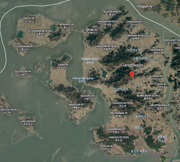
- Mangwolpyeong Plains: Drive through the northwestern part of the island to view massive agricultural fields that were once open sea. The sheer scale is breathtaking.
- Manisan: When hiking this famous peak, remember you are standing on what used to be a completely separate island before Joseon engineers bridged the gap.
- The Stranded Dondaes: Seek out the inland fortlets. Observing these coastal defenses separated from the shoreline is one of Ganghwa’s most unique visual ironies.
💡 Pro Tip: Before visiting the fortresses, rent a car or take a bus tour through the western farming districts of Ganghwa. Seeing the endlessly flat reclaimed plains first makes the island’s military and geographic history much easier to comprehend.
Explore More of Korea
If you are planning to delve deeper into Korea’s historic sites and natural wonders, check out these helpful guides:
- Ganghwa Island Day Trip Guide: Korea’s Historic Time Machine
- Suwon Hwaseong Festival 2026: Dates, Parade & Travel Tips
- Korean Mudflat Experience: Clam Digging Guide
- Exploring Donggureung: Korea’s Largest Royal Tombs
- Top 10 Autumn Festivals in South Korea to Experience in 2026
Korean Culture portal KCulture.com

Founder of Kculture.com and MA in Political Science. He shares deep academic and local insights to provide an authentic perspective on Korean history and society.